


Claude Nicolet, Space, Geography, Politics Early Roman Empire
Real and symbolic control; calculation of society changed society; the arts of the geometers, mathematicians, technicians; codes, signs, letters, abbreviations, etc.

Claude Nicolet wrote:
Space, Geography, and Politics in the Early Roman Empire
Introduction
Rome had an empire before becoming an empire. Of all the ancient cities (Athens, Sparta, Carthage, or Syracuse) it succeeded in conquering and preserving for at least two centuries vast territories dispersed over a wide area. Such expansion was felt by contemporaries to be inevitable and without bounds. After two centuries the republican structure of the Roman State, apparently incapable of adapting to this new territorial scale, collapsed in the turmoil of civil wars. The City became a monarchy: an emperor governed at Rome. It was what is known as the Roman “empire”. …
… In order to set boundaries to their empire and to claim to have reached those that were marked out, the Romans needed a certain perception of geographical space, of its dimensions and of the area they occupied. Yet this space was forced upon them to the extent that they had to become or remain its master, to dominate its overwhelming distances, to recognize and exploit its resources, to gather information and convey orders from one end of the empire to the other, to assemble troops or have them patrol this space. The ineluctable necessities of conquest and government are to understand ( or to believe that one understands) the physical space that one occupies or that one hopes to dominate, to overcome the obstacle of distance and to establish regular contact with the peoples and their territories (by enumerating the former and by measuring the dimensions, the surfaces and the capacities of the latter).
The objective is to know how the Romans, at a turning point in their history, became aware of this and adapted. …
… What interested me is not so much the spatial and territorial reality of the Roman Empire at its foundation, but the awareness of it possessed by the main players: the Romans and their adversaries, the ruling classes and the subjects. In a study such as this, geography should not be understood as a reality but as a representation of that reality. Like all sciences, in any case like history, geography is both the object of a study and the study itself, in its approaches and its results.
I mean "representation" of the earth and of the geographical space in the full sense of the word. Since it concerns geography, this representation offers the proper traits to the various processes of knowledge (intuitive or deductive, mythical or rational, practical or theoretical). It is transmitted by words, by logos, by discourse, by a speech given from the rostrum or read in the quiet of a reading room. Like all sciences, it moves cumulatively: all sorts of progress, some empirical and others theoretical, slowly create a body of knowledge more or less imperfect and more or less accepted by society. But concerning geography, the frontier between the known and the unknown is first of all traced on a territory, in a space: the world is still a partly unexplored piece of land. Whence the fundamental notions, according to the concepts of that time, of the known and unknown world, of the inhabited or inhabitable earth. Geography-knowledge and representation of the earth-is still at the stage of voyages and discoveries: "inaccessible" spaces still remain. As for what is known, or rather surveyed, the first stage of understanding passes through different descriptive methods: such and such a thing in such and such a location, before or after such and such a thing, which is little else than an imaginary voyage.
At the same time the advancement of mathematics and science led another geography, based on astronomy and geometry, to remarkable results: to the identification of the world as a sphere (the globe), situated at the center of the celestial sphere and on which were projected "noteworthy circles and points": the poles, the equator and the tropics. In the third century B.C. it was even possible to measure the length of that sphere with stunning precision and to locate the "known world" with adequate exactitude, owing to some systems of projection of which the most perfected, those of Ptolemy (conform conical projections), are still in use. Hence a scholarly-and even theoretical-geography evolved that was able to trace the general frame of the planet that explorations, commercial links, astronomical and gnomonic observations, and measurements by geometers or military engineers would allow to be perfected, within the limits of the existing techniques.
This geography (representation through discourse, description, an account of a voyage, or an itinerary and geometric conceptualization) also comes with a cartography, or rather, it is cartography. In antiquity the same words specify discourse and drawings. Drawing and writing are complementary processes. The vocabulary of ancient geographers is a language similar to that of modern geographers. It uses words, signs and pictures, symbols, and even colors. The distinction lies with two types of geography and cartography ( a usage that lasted until the seventeenth century) that are differentiated essentially by scale. "Geography" traces the contours of continents and shores, on a small scale, and places regions or provinces-in a system of projection-by giving them form and dimension. “Chorography" is regional geography and cartography, on a larger scale and with far more details. Since the word also signifies (and definite proof of this does exist) the art of the geometers (military and civilian), we pass from regional chorography to "topography;' which illustrates, and marks within a plan (forma), the cadastre of a city or of a town. It involves—from the planisphere to the cadastral survey—a series of representations that have a common geometric base, an assessment, and, supposedly, an exact representation of the surfaces. In brief, it is a source of reference that includes the areas by a gradual and uninterrupted series of transmissions, in the whole world and even in the cosmos.
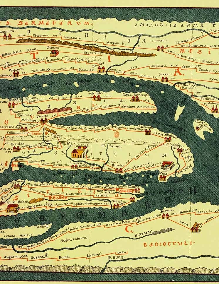
Geometry and astronomy are equally indispensable to the geographer and to the geometer, as confirmed by the unanimous classical tradition from Polybius and Varro to Cassiodorus and Boethius. But other methods of seeing the world and comprehending space were also open to representation. Travel (by land or by sea), whose practical importance is evident, can also be expressed graphically. The route becomes a linear network with distances and intersections carefully noted in one dimension. lntercalary distances, like correct orientation, are less important than the actual mileage or the noting of ports, stopovers, lodgings, granaries, or other noteworthy spots. Whence the "painted itineraries;' of which the Peutinger Table provides the most striking example. Certainly it is a way of understanding and representing space that follows schemata other than a map or a plan, but it is not incompatible and can be used jointly.
Yet all these representations, soundly empirical or audaciously theoretical, depended upon the physical possibilities and techniques of men of that time. They were aware that these representations entailed considerable unknown territory and consequent error. It involved the inventory of a domain (the inhabited or habitable world), which had to be accomplished by continuous advancement. Worse yet, at the edge of the unknown, mythical thought prevailed over rational thought, although it was less marked than in other periods. After all, the realities of the cosmos (the heavens, the sun, the earth, and the ocean) were divine beings for the ancients. The scientific representation of the two concentric and identical spheres ( the terrestrial in the center of the celestial) did not prevent the majority of people from feeling strongly about sensory illusions, to take metaphors more literally than we think: “le soleil se couche a l'ouest, dans l'ocean." Whence the sacred nature of the mystery and, by a series of predictable shifts, the prestige attached to the survey or to the conquest of certain zones-in particular, the confines of the known world (represented as an island surrounded by the sea) towards its oceanic shores. …
… Is it possible to discern an administrative geography of the empire at its foundation? Curiously enough, this second question has practically never been approached in a manner that interests me. Roman administration has been dealt with extensively. As to its history … the preoccupation was with personnel and its recruitment rather than its function and activities. Epigraphical and papyrological sources directed scholars in their research. This led to a minute and indispensable understanding of organization and the cursus honorum. In addition, scholars have identified the different provinces of the empire and studied their towns, roads, and military or nonmilitary settlements-but always according to modern maps.
Yet this history of administration has had little interest in the real administrative workings of so vast a territorial empire; that is, how the contacts between the adminstrators and the administered were organized and handled; how information necessary for decision making was gathered and circulated, and how commands or instructions reached their destination. It is not a matter of considering the judicial basis or content of administrative acts, nor is it a matter of competence or hierarchies. It is necessary to question concrete procedures inasmuch as they fit into space and time. As it applies to people (i.e., transportation by land or by sea, and communication), this study is related to the history of techniques …
… The fundamental classifications of a city are personal and not territorial, and this arrangement cannot endure when the territory is too large. Even if the civic link is felt as strongly as before, it will be expressed and organized in a different manner. Therein lies the new importance given to the written word. People and their possessions, as statistics, will be represented by documents whose originals or copies will travel back and forth between the center and the periphery. Once listed, classified, and stored, these documents will constitute, at the center of power, an administrative memory and picture of the world that will correspond more or less to those geographic images that we have studied. It is natural for the census of populations and the inventory of landed properties to insert themselves into the measurement and representation of space about which the government had taken the initiative, and which it used for its glory and justification. But here again there are emblematic synchronisms. …
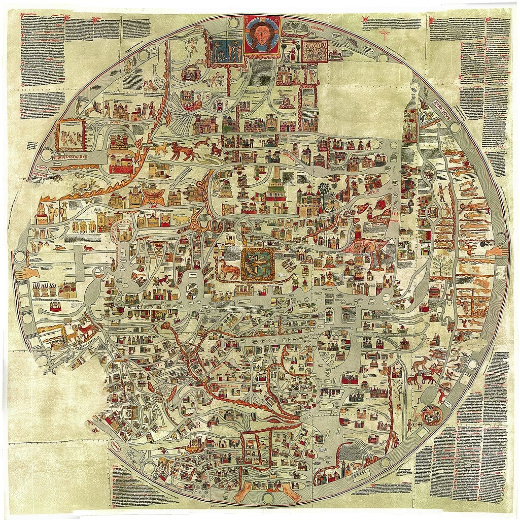
Ebstorf Map [It is illustrated in the book but it is not Roman]
CHAPTER VI
Control of the Human Sphere: The Census
It is not enough to have conquered the world, or even to declare its conquest. The inhabitants of the urbs, flattered by this idea since the triumphs of Pompey in 61 B.C. and Caesar in 46 B.C., were no doubt content with the proof provided by the arrogant litany of geographic names in the Res Gestae, by the symbolic layout of Augustus's Forum, or by the map of the oikoumene in Agrippa's Porticus. But those in power had to face a less flattering reality. It was not sufficient to know the approximate extent and limits within the oikoumene of the world that they had to govern—they had actually to take possession of it. By the end of the Republic and especially by the beginning of the empire, the Romans were becoming more conscious of the strict limitations of their imperial domination and, in some ways, of its fragile nature: on several occasions they had perceived that it might exceed the capacity of their strength and resources. They knew very well—Cicero, for example, often reminds them—that it could only endure if it was actually accepted, that is to say, if their government represented a clear advantage for its subjects.
The first benefit was internal peace … But also there was prosperity, along with good administration and the attempt at sparing-as much as possible—the lives and possessions of the subject peoples. In short, it meant that resources had to be adjusted to the government's expenditure in the most exact and bearable way possible. … Such was the goal, but also the condition, for the maintenance of the empire.
To achieve this, it was not enough to be complacent about old victories. It was necessary to act and govern. And for this it was necessary to have clear and precise ideas of the empire's resources, and of the expenses required for its maintenance. Before any action could be taken, there was the problem of information available to the government. This was not a new problem;
the Late Republic had had the same difficulties. Cicero often insisted upon the need for comprehensive information and for a real "science" of government. … Unfortunately Cicero does not mention where his ideal statesman should get his information and his science. Apparently everything is considered from an individual point of view: the individual should train and inform himself as best he can. In fact, we know very well that in this oligarchic republic, many things were of the private and familial sphere: the statesmen often counted on their network of clients, on their personal links with a particular province, and on the information (learned or otherwise) that their literary or social circles could provide. Their success or supremacy rested upon this.
Yet there were also public sources of information. The Republic did not manage its day-to-day affairs-as some have suggested-without archives or administration. There were public archives (tabulae publicae) for every type of affairs that were the responsibility of competent magistrates. Many among these-such as financial accounts and affairs, but also texts of decisions, laws, and senatus consulta-were, in theory, kept in the Treasury of Saturn, in the quaestors' care … [and] the archives were indeed scattered throughout Rome.
Furthermore, their upkeep at the end of the Republic was in a state of abandonment and neglect, concerning which there is much proof, and which was deplored by the more conscientious statesmen. As quaestor in 65 B.C., Cato the Younger undertook a spectacular reordering of the Treasury's accounts, which had been allowed to be plundered with the complicity of scribes and of certain important persons. … But negligence was not the only problem. Entire sections of the administration—especially in the financial sector—escaped state control ( at least directly): that is, the accounts of tax-collecting societies. Even if a copy of a five-year contract were deposited in the censors' archives, the annual and monthly breakdown ( which alone was probable) of the accounts of taxes was found only in the local accounts of provincial promagistri, and eventually, as copies in the hands of the magistri and ex-magistri of the societies. Cicero's difficulties in acquiring documents for his case against Verres in 70 B.C. show that this was a great weakness in the system (2 Verr., 2.169-82; 187). …
… We have seen that Augustus, throughout his reign, sought to make knowledge and representation of the imperial sphere more precise, which ultimately implied the creation of a geography, a chorography, and even a cartography that were coherent and progressively improving. But there is not only the physical sphere to be considered: there is also the human sphere in administrative and economic terms, whose control depends on the mastery of statistical information concerning it. That is to say, the preparation and the consultation of documents, at all levels of power, is necessary in order to know and to command, in order to be correctly informed and to keep one's subordinates well informed. Therefore, an administrative history of the empire at the crucial moment of its foundation must proceed first, it seems clear, with an inquiry about its concrete and logistical functioning.
First of all, we need to set forth a history of the documents on which the administration was based, how they circulated between the center and the periphery, as well as their final concentration in the hands of one man—and then their eventual publication or diffusion. … I will only consider the documentary sources that are essential for the control of men and their resources, that is, the various censuses of people and goods, and the global evaluations they made possible. They are the precise mark of the change that the foundation of the empire represents. I will deal successively with … (to use a modern term not entirely pertinent). The two institutions can only be separated for the convenience of this expose. In most cases, the two were inextricably intertwined. A census was never taken at Rome without including possessions, and the possessions (landed or otherwise) came under so many different statutes (from the fiscal point of view) that their owners almost always had to be taken into account. …
The complex operations to the census were the keystone of the Roman civic system. It made possible both the knowledge of the city's resources—in terms of available men and goods—and the ranking of citizens according to various criteria ( the most important of which was patrimony), so as to divide up the responsibilities and the advantages of state policy ( especially war). This solemn operation that, in the literal sense, organizes the city and gives it life, also punctuates its history with majestic continuity, for least as long as its dimensions remain true to its nature, and makes it possible to master these operations easily. From the fifth to the second century B.C., the main characteristics of the census operations were its meticulousness, its solemnity, and its physical repressiveness. The citizens (at least those who were sui iuris) were required to present themselves before the censors and their employees to declare under oath, their age, family, and all of their goods.
The lengthy operations took place at Rome in the Campus Martius in an enclosed space, where the citizens were summoned by tribes, thus in successive groups. Until the second century B.C., physical presence was obligatory except in rare, legally defined cases. Originally, absence was punishable by loss of civil rights, loss of liberty, and the sale of one's belongings (Cicero, Pro Caec., 99). Thus during the Republic, the Roman state was always able to update the general size of its population and the extent of its resources. …
CHAPTER VII
Control of the Fiscal Sphere: The Cadastres
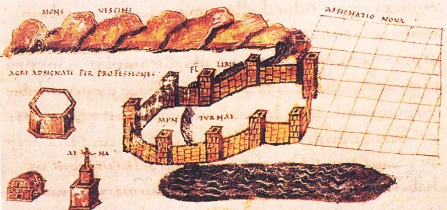
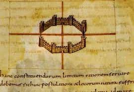
We have seen that in the provinces, populated for the most part by noncitizens (subject to taxation), the census operations regarding individuals could hardly be distinguished from a parallel inventory of their property—especially real and landed property. On this last point, the Romans of the Late Republic and the Augustan period had at their disposal proven techniques and a long tradition. In progression with Eastern, Egyptian, and Greek techniques, the Romans, like other peoples of Italy, for centuries organized their territory—especially their newly conquered territory—in light of its agricultural exploitation. They did this not only by surveying it and determining the boundaries between private and public property, but also by actually "constructing" it on the terrain. They enclosed it within vast systems of roads intersecting at right angles and defined by a precise orientation around two axes, which extended to the limits of the territory in question. These geometrically defined roads outlined square or rectangular units (centuries) which then served as the basis for the distribution of lots or parcels to future recipients. The existence of roads and of relatively close boundary stones fused and perpetuated, to some degree, the collective framework of the possession of land and of its development in the landscape itself. For the Romans, these operations were linked directly to conquest, to the adjustment of the status of those who had been conquered, and to the eventual or actual expropriation that resulted in the redistribution of land to Roman colonists or to individual recipients. The major phases of Roman colonization or of individual grants of land to Roman citizens had spanned the history of Italy, Cisalpine Gaul, provinces like Spain, Africa, and Narbo nensis, and soon of the entire Roman world.
Since it was necessary to determine what belonged to the Roman people (for distribution) and what could be given back to the previous inhabitants, and—in addition—to revise what had been done each time a new operation affected an old territory, the network of "centuriation" gradually spread out, sometimes superimposing itself upon large territories. These operations were all the more necessary (and in the eyes of the ancients they derived all their meaning) on account of the status of lands, which—in a society that was inegalitarian in principle—was among the most varied.
The status of persons was equally varied. First, the recipients, whether veterans or civilians, were privileged individuals; their lots (which they received free of charge from the State) had to be exempt of all taxation and rent. When the assigned or granted lots formed part of a collective foundation (most often a colony), the responsible officials in turn gave this new community collective land, in addition to the "divided" lots, which it could exploit by renting, leasing, or giving away. Whence came the necessity to define clearly not only the boundaries but also the legal nature of the land. In principle, and at the outset, this type of description of a territory, with its diverse allotments, was devised to be permanent and to settle various categories of farmers on the land who, the government hoped, would carry on. During the foundation of most of the colonies and in certain large settlement projects (those of the Gracchi and Caesar) the lots were even inalienable in principle. However, these legal stipulations were not respected for long. In time, interventions of all kinds would occur—sales, inheritances, exchanges, rentals—but the original status of the land was often retained. And in all cases where the property of the State (or of the local community) had not been formally alienated for the profit of specific beneficiaries of the ius Quiritium, the possibility of recovery always remained.
This explains the important role played in the Roman civic system (which spread out gradually, on provincial soil, to the edges of the empire) by specialists responsible for defining the physical space and the legal nature of the land and for specifying its rights. Following Greek and Eastern practices, the Roman State employed indispensable technicians, the mensores, for this task: the mensores aedificiorum for the built-up urban spaces and the agrimensores for the open countryside. Of course, these men were first of all geometrai and as such, they were specialists in surveying techniques, in centuriation, and even, as we shall see, in the distribution of lots on the land itself. But these mensores also had legal responsibilities; not, of course, in the actual granting of lots (Agennius Urbicus, p. 8, 26 L), which fell within the competence of the Senate, the people, and the magistrates; or in trials concerning questions of ownership, boundaries, etc., which in principle fell under the jurisdiction of a judge. But they were legally responsible for the definition of the boundaries and of the private or public nature of the lots: they made an evaluation (renuntiatio) which, eventually, would support legal action. Thus they were personally responsible and could be liable to an action de dolo malo (Dig., XI, 6). And as we shall see, they were required to back up these appraisals with certain documents.
This is roughly the situation at the end of the Republic. At this time, the mensores (or the finitores for the plots) fell into two categories. Some were private and employed by the privati (and were often of humble means); others belonged to the military-soldiers or officers who often specialized in castrametation, and who sometimes played a role in political history (like those of Antony scolded by Cicero). Still others might-temporarily or not be employed by magistrates; this group … was entrusted, on authority, with a great power of appraisal and of arbitration, for example for the recovery of public land.
But later, in the Early and especially the Late Empire, the ties between the administration (even justice) and the agrimensores grew stronger. In some regions, the military authority was entirely responsible for the centuriation and the division of land… Elsewhere, a mensor who was designated by the emperor brought in a verdict. Finally, at least from the time of Constantine, there was a corps of official mensores recruited by competition (professiones), with a primicerius … at their head. This hierarchy of technicians naturally implied a culture, a transmission of all types of required knowledge, and perhaps, later on, an organized training program.
Our knowledge of this, indirect and incomplete but still impressive, comes from the collection of technical texts which modern scholars have gathered as the Corpus agrimensorum or the Gromatici. In general, these were school texts compiled quite late. But—even if they are badly preserved-some treatises go back to the first and second centuries A.D. Most embrace the whole of the required knowledge of the ars: the module for defining boundaries, names and types of measurements, diverse statuses of land; techniques for defining boundaries, for centuriation, and for calculation in the field; types of controversies; summaries of great historical projects of allotment and colonization, especially in Italy; finally—and this is what interests us—transcription into graphic documents (plans, maps, etc.) of surveys or operations done in the field (codes, signs, letters, common abbreviations, etc.) and drafting techniques. It is remarkable that the most complete or the most ambitious of these manuals intentionally puts the art of the geometer back into the complete body of knowledge (according to the model found in Vitruvius for architecture, and in Strabo for geography), first linking it to cosmogony (the knowledge of the mundus, of the Universe), and then to cosmography (the knowledge of the orbis terrarum) … and then to mathematical geometry. In these parallels (of which there are traces in Cassiodorus and in Pseudo-Boethius), reference to the Augustan period turns up insistently. …
… It is clear that these operations had always been translated into written and graphic documents. …
Another series of public documents also contained landed, if not cadastral, information; these were the leges given to colonies (or to municipia) by their founders or by those responsible for the distribution of land. They had to determine, among other things, the status of the road system, the boundaries of the collective land of the foundation, etc. …
… The mensores had to be able to draw up actual maps of the lands for which they had done the cadastration. Their manuals often describe these operations. The generic term for these plans is forma, but there are many synonyms: tabula, pertica, typon, metatio, etc. These formae were drawn up on flexible materials (parchment or paper), but they were also engraved on bronze, and only the latter could really be trusted: ilia tantum /ides videatur quae aeris tabulis manifesta est. A treatise like the De limitibus constituendis of Hyginus Gromaticus is entirely devoted to the method of transcription and to the technique of drawing up these formae: geometrical techniques , then conventional notations and symbols, the same as on the boundary-stones (pp. 194-95, 196-97: quatenus erit, inscriptione replevimus, ut et in forma loci latitudinem rarior litterarum dispositio demonstret). When it is a question of land distribution, there are codices that correspond to the forma of the land in question, made up of several pages or registers, on which are written the names of recipients chosen by lot …
… In short, the evolution of the property—through purchase, sale, exchange, or inheritance—could profoundly modify the cadastre and might lead to confusion between land that had been surveyed and land that had not, making any inquiry exceedingly difficult … This is why individual landowners, even for lands that, in principle, were not centuriated and thus not drawn on a forma, had plans drawn up at their own expense. However, such plans would have no legal force …
… Finally, I maintain the probability that a "manual" or a liber existed written by an agrimensor of this period … Thus, there were centralized cadastral archives with varying degrees of elaboration, based on basic dossiers.
But there is more. We have good reason to believe that documents of a cadastral nature existed at Rome and in Italy earlier still. First of all let us begin with Rome itself. The famous forma urbis, of which impressive fragments survive, proves that detailed plans of Rome (and certainly of other cities) did exist. Of course, it is not a cadastral plan, but rather a prestigious monument connected to the Prefecture of the City and displayed on a wall of the Library of the Temple of Peace. … The plan gives everything: the road system, public monuments, private houses and buildings, with coherent symbols to show staircases and second floors. Finally, the names of monuments or neighborhoods were included. But this is not a cadastre: there are no measurements or parcels of land. …
… But we can go back still farther in time. It is more than likely that documents of a cadastral type existed in Rome in the Late Republic, around 75 B.C., or by 45 B.C. at least. The collection of laws or of municipal regulations of Roman origin transmitted by the famous Tabula Heracleensis … contains a series of stipulations regarding the maintenance and the repair of urban public roads. The general principle is as follows: maintenance and repair were the responsibility of the (private) owners of properties that border on the public road. …
… We have seen that, at least from the time of Caesar, the censuses for the inhabitants of Rome were done "through the intermediary of owners of all the buildings” … street by street, which implies a statistical list of those owners of tenement houses. This evidence, along with the Tabula Heracleensis, confirms the existence of books, if not of plans, of a cadastral nature.
In each case, in order to contact the actual owners it was necessary to be aware of property transfers, and not, as in the agrarian formae, the original recipients. Registration of transfers of urban properties is attested, from the beginning of the first century A.D., for the allotment of rights to water from the aqueducts …: "as soon as any water-rights are vacated, this is reported, and entered in the records" (cum vacare aiiquae coeperunt aquae, adnuntiatur et in commentarios redigitur . .. ). Likewise, we have seen that death registrations are implied in Caesar's legislation concerning grain distribution … Here too, we must assume that there was a declaration of transfer. As far as the Tabuia Heracleensis is concerned, such declarations might very well have been part of the regulation itself. The first twenty lines of the inscription (whose beginning is missing) concern mysterious “declarations" that must be issued periodically by individuals who, as we have seen, could be citizens (minors or majors); declarations that are clearly of a patrimonial nature. I propose that among the individuals to whom this document is directed are included those of … "the ones before whose building one of these public roads is located" (ii quoius ante aedificium earum quae via erit). If this hypothesis is correct, we would have proof not only of the existence of a cadastre, but also of a declaration and registration of transfers of property (cf. Cicero, Att., 13.33.1; and Fam., 16.23.1).
… A passage in Theophrastus shows that the concern officially to register property sales was relatively widespread in Greek cities. The case of Tenos is doubtless explained by the special and quasi-fictitious character of these sales, since they concerned, in most cases, the lifting of mortgages that generally involved the management of dowries or of inheritances. Apparently there is no question of taxation or of a distribution of expenses. It is not a cadastre.
But it is essential, on the other hand, to compare the conclusions that we have drawn from the Tabula Heracleensis and the testimony of Cicero and Suetonius with what the papyrological documents teach us concerning the practices in Egypt … types of declarations, resulting in the collection of documents whose usage can be compared to the practice in Rome, are of interest to us. …
… It is generally thought that the public registration of private acts, which is at the origin of our notary profession, was a characteristic peculiar to the Greek provinces of the empire (including Egypt) and that it did not extend over Roman law until the fifth century. Maybe so. But it seems quite probable that, for certain acts that might have important consequences for the use of a property (like taxation, maintenance, water concessions, or population control), the State—at Rome, in Italy, and in the provinces—must have been keep informed long before that late date. This was already the case when the section of the law at the beginning of the Tabula Heracleensis was written that implies the identification, at all times, of owners of urban buildings and the knowledges of the size and value of their property. To achieve this, a regular system of declaration and registration of the shifts in property had to be devised. In my opinion, cadastral matrices and an office of acquisitions or mortgages, or probably both at the same time—in one form or another—must have existed at Rome at least by the first century B.C. Documents must have existed that are forerunners of those of which copies or echoes of a much later period have come down to us, like the Forma Urbis or the Regionaries. The Tabula Heracleensis is proof of this, and it can prompt us to shade the primitivist vision often presented to us concerning Roman administration during the Republican period.
CHAPTER IX [final]
The Administrative Organization of Space: Urban Regions and Italian Regions
… [It] is clear that geographical space, within the boundaries of the empire, is also and perhaps above all an administrative space. This point may seem banal; actually it marks an important change, a notable modification in the perception of space and, undoubtedly, in Roman administrative procedures.
This deserves a closer examination. That the government of men, the administration of resources, and territorial organization coincide and occur in some sense within the same space is a modern concept self-evident to us. This was not the case in GrecoRoman antiquity. Cities or kingdoms could certainly have territories precisely demarcated by zones or even boundary lines. But the concept of territory is never enough to define entirely and exhaustively their true organization and, in particular, their operation. There were several reasons for this. First, in most cases, the territory was not neutral: it was viewed as having a relationship with the cosmos, religiously oriented and pervaded with sanctity. On the other hand, in inegalitarian and, as the anthropologists say, "segmented" societies, the men within the territory are not interchangeable individuals. They are naturally part of their families' lineage, they belong to associations, and they possess varied status that often has no territorial basis but depends on race, religion, or specific legal standards. Most often … these various memberships (which in fact did not coincide and which generated different classifications) determined the real structure of administrative and political life. Rome was no exception to the rule. …
… Within the Roman imperial space the concepts of center and periphery are extremely clear. There was a caput to the immense “body" that was the empire: it was both the city of Rome and the emperor—as everyone would repeat ad nauseam in A.D. 69-70, during the first great crisis of power that saw emperors proclaimed outside of Rome … That the center of power would remain at Rome was not necessarily obvious. Augustus's first and most evident concern was the assertion that the center of power would remain fixed geographically, politically, and spiritually at Rome itself. …
… But it cannot be by chance that it is in the work of the architect Vitruvius, completely engaged in the aedilician program of the new princeps, that we find between 24 and 20 B.C., but now linked to the imperial destiny of Rome, the concept that this excellence puts Rome and Italy in the center of a world that they must dominate.
Such being nature's arrangement of the universe, and all these nations being allotted temperaments which are lacking in due moderation, the truly perfect territory, situated under the middle of the heaven, and having on each side the entire extent of the world and its countries, is that which is occupied by the Roman people . . . Italy presents grounds of praise for its temperate and unsurpassed (climate) . . . Thus the divine mind has allotted to the city of the Roman people an excellent and temperate region in order to rule the world. (Vitruvius, 6.1.10- 12) …
… If my first hypothesis is correct—that is to say if, somehow, the votes of a colonial city were recorded together and in one single register-another comparison with the extraordinary Tabula Heracleensis comes to light. We have seen … that, based on the stipulations of the latter, the registers of the census that had been taken locally by local magistrates according to Roman rules had to be sent to Rome and transcribed into public registers, which would be archived in the same offices as the registers of the Roman census. If we follow the particulars of the text, it seems clear that the results of the local census were not registered purely and simply in the blank spaces of Roman books, but that they consisted of separate and, in some way, autonomous registers. I see no other classification for these registers than a geographical one.
The traditional classification of the census is the tribe. Formerly, the registers were those of the tribes; but what was now being brought to Rome and transcribed into other books, was not the census of, e.g., the tributes of the Falernian tribe, but rather the register from Heraclea or some other city where there were citizens of different tribes. How to arrange these registers, if not in a topographical order? In the same period, we have seen that the urban census ordered by Caesar was taken vicatim; here again, I doubt that the resulting documents could have been otherwise arranged.
Such a process was a serious break with the traditional system of tribes and centuries, which implied, by its centralization at Rome, a considerable and henceforth impossible physical mobility of people. The parallel with the somewhat earlier procedural changes in the census is certainly not fortuitous. The same answer was given to the challenge that traditional institutions faced because of the expansion of the Italian political arena: substitute the mobility of documents for the mobility of people, decentralize the operations in order to centralize the results. The empire could not function without a series of representations where the clear consciousness of space depended on the primacy of the document. Under these conditions, it is not surprising to see the gradual disappearance of the old timocratic, familial, or personal structures—like the tribes or centuries—which favored men instead of space, and social and legal status instead of topography.
With the tribes thus reduced, by convergent paths, to a purely honorific role, I believe that we can better understand the appearance of the Italian regions. In my opinion, this can only have been grosso modo contemporary with that of the urban regions. Their name itself-regio-asserts their neutral and exclusively topographic character. In fact, it is a word borrowed from the vocabulary of the geometers: a zone of space determined by lines of an astronomical character …
The Source:
Claude Nicolet*, Space, Geography, and Politics in the Early Roman Empire, University of Michigan 1991 [Originally published as L'Inventaire du Monde: Geographie et Politique aux Origines de L'Empire Romain, Librairie Artheme Fayard 1988]
*b.1930-d.2010
[MGH: Pictures are illustrated at back of book, I found better colour images.]
Evolutions of social order from the earliest humans to the present day and future machine age.